The Urban Water Planning tool (UWP) is part of URBRAINS, the Dareius Toolbox in which we have collected our different analytical tools for complex urban water problems. The combined implementation of these tools will make cities more resilient and more sustainable.

Why the UWP?
European governments face the common challenge of making cities more resilient, robust and predictable in their behaviour. The challenge has to be faced as a precaution against the sometimes capricious consequences of climate change. And the challenge is enormous. It entails equipping our cities with key infrastructure and a green energy supply. But it also concerns the quality of nature, within which urban green spaces are an important part. All of this demands an integrated approach. Water in the City typically plays a central role here. But we now have built up a great deal of knowledge in the area. This has generated the need for a practical evaluation framework, and for a tool to support the use of all this knowledge in a practical context. Today’s solutions must increasingly connect with the world of tomorrow. A world subjected to the process of increasing climate change. This is what drives our concern about adaptive and effective infrastructure, such as sewer systems, drinking water infrastructure and the foundations of old and new buildings. All of this, with an eye to a green and healthy city. The UWP is a digital platform that enables the combined visualisation of different tasks, and the clear representation of the details of the impact of concrete measures. The tool is connected to our Digital Twin approach.
How does the UWP work?
The UWP offers a digital platform which brings together the different dimensions of the climate-related, urban water challenge. It is a powerful tool with which to translate a wide range of data into an optimal design to address a specific set of problems. Water is the central organising principle. The UWP puts water proactively on the map, highlighting both the opportunities and risks. With the UWP, water ‘free-rides’ on other developments in the city. It is founded on the concept of the complex urban (water) system. The approach opens huge opportunities for ‘working with work’ – for example, in
the case of urban infrastructure renovation projects. That is, by tackling already planned developments with the aim of giving them a resilient and robust orientation. All of this in coordination with residents and local authorities, along with the application of multiple professional skills.

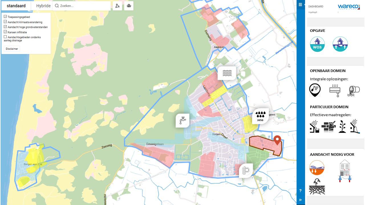
Screenshot of the Urban Water Planner
Setting to work with the UWP
Drawing on generally available information about the water system, we create interactive maps and flesh them out with data available to governments. We help translate urban development plans into risk and opportunity maps for issues like flooding, drought, land subsidence, historic building protection, and possibilities for the storage (Urban Water Buffer NG) and the discharge of (ground)water. The solution pathways at the city level go hand-in-hand with the elaboration of related measures. The UWP supports the process of joint decision-making. It is interactive and deployable, both at practical and operational levels. It is also suited to the exploration of options with residents and managers in participative processes with short lead-times. The UWP provides a universal entry-level model. Whether there are too many or too few data, the UWP produces reliable, transparent and traceable results, on the basis of the data that are available. This means that the UWP provides a growth model with which, over time, with the addition of new information, insight can be extended efficiently and reliably.
Do you have a UWP idea?
Do you have your own idea about how the UWP can be used in your specific situation? Are you wondering about how you could get a complex project underway in this context? We would be happy to share our experiences with you and explain our growth model.